


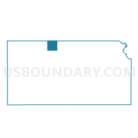
Mound Township Voting District, Phillips County, Kansas
About
Outline

Summary
| Unique Area Identifier | 586279 |
| Name | Mound Township Voting District |
| County | Phillips County |
| State | Kansas |
| Area (square miles) | 35.94 |
| Land Area (square miles) | 35.94 |
| Water Area (square miles) | 0.00 |
| % of Land Area | 100.00 |
| % of Water Area | 0.00 |
| Latitude of the Internal Point | 39.78491140 |
| Longtitude of the Internal Point | -99.45917450 |
Maps

Graphs
Select a template below for downloading or customizing gragh for Mound Township Voting District, Phillips County, Kansas


Neighbors
Neighoring Voting District (by Name) Neighboring Voting District on the Map
- Beaver Township Voting District, Phillips County, KS
- Belmont Township Voting District, Phillips County, KS
- Dayton Township Voting District, Phillips County, KS
- Freedom Township Voting District, Phillips County, KS
- Logan Township Voting District, Phillips County, KS
- Phillipsburg Township Voting District, Phillips County, KS
- Prairie View Township Voting District, Phillips County, KS
- Solomon Township Voting District, Phillips County, KS
Top 10 Neighboring County Subdivision (by Population) Neighboring County Subdivision on the Map
- Logan township, Phillips County, KS (637)
- Phillipsburg township, Phillips County, KS (259)
- Solomon township, Phillips County, KS (201)
- Prairie View township, Phillips County, KS (200)
- Mound township, Phillips County, KS (144)
- Belmont township, Phillips County, KS (90)
- Freedom township, Phillips County, KS (90)
- Beaver township, Phillips County, KS (55)
- Dayton township, Phillips County, KS (33)